
On July 7, 2026, Hacker News — the news community with the highest concentration of programmers on the planet — saw its front page dominated by something that wasn’t a large language model, a chip fabrication node, or a Big Tech quarterly earnings report. The day’s top story, at 662 points, was a small Android app called StreetComplete. Its functionality, described plainly, sounds absurdly simple: as you walk down the street, your phone pops up a small question — “Does this intersection have a traffic light?” “Is there a sidewalk on this road?” — you glance at the real world, tap the screen once, and you’re done. Your answer then becomes a real piece of map data, written into a global open-source map called OpenStreetMap.
No leaderboard, no virtual coins, no streak bonuses. It barely even qualifies as a “game.” And yet, across 162 comments, the word that kept coming up was: addictive.
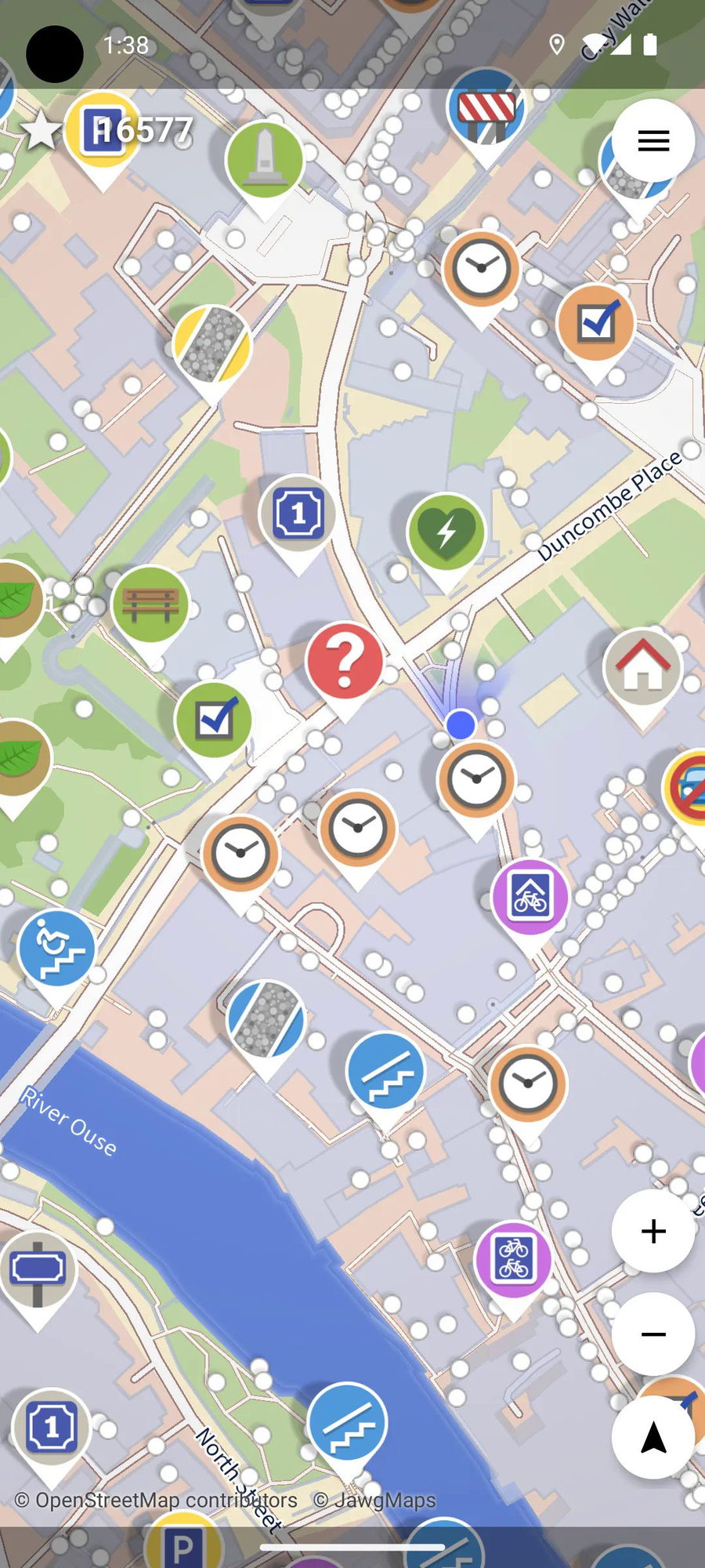 ▲ StreetComplete’s main interface: every marker on the map is an unsolved “quest” — answer one question and you’ve repaired a piece of map data (source: streetcomplete.app)
The Map on Your Phone: Where Does the Data Actually Come From?
Before we talk about StreetComplete, let me ask a question that sounds almost too basic: how does the map app on your phone know that the street ahead is one-way? How does it know there’s a café in that building?
Most people’s intuitive answer: satellites took pictures. Or: map company employees drove around taking pictures.
Both answers are correct — but only a tiny fraction of the story. Satellites can capture road shapes, but they can’t read the number on a speed limit sign. Google’s Street View cars can photograph storefront signs, but they can’t tell you what days the shop is closed, whether it’s wheelchair accessible, or whether there’s a ramp at the entrance. The details you take for granted when navigating — sidewalk locations, trash can distribution, drinking fountains, streetlight coverage — are overwhelmingly the kind of fine-grained data that map companies can’t afford to cover. There are too many roads in the world; the Street View cars can’t reach them all. And even where they’ve been, road conditions change every day: shops open and close, buildings are demolished and rebuilt, sidewalks crack and get repaired.
So how does Google Maps solve this? The answer is: to a large extent, it doesn’t. There’s an open secret in the mapping industry — outside the central districts of a handful of major cities, map data across most of the globe suffers from significant lag, gaps, or outright errors. You’ve probably experienced this: navigation guides you onto a dead-end street, or shows a restaurant as open when you arrive to find it closed three months ago. Behind this lies a fundamental ceiling on the centralized map data collection model: no single company, no matter how wealthy, can afford to maintain a ground-survey team covering every corner of the planet.
And that’s where OpenStreetMap — the platform StreetComplete feeds into — takes an entirely different path.
The Wikipedia of Maps: Anyone Can Edit, and It Gets More Accurate Over Time
OpenStreetMap (OSM) can be understood as “the Wikipedia of maps” — a global map database that anyone can use for free and anyone can edit. It was founded in 2004 by a British physics student named Steve Coast, with an initial motivation that sounded like a university final project: build a free world map that isn’t controlled by commercial companies. Twenty-plus years later, OSM has over 10 million registered contributors and is used as the underlying map data source by Apple Maps, Facebook, Uber, Amazon Logistics, and even some national government agencies.
Its operating model is near-identical to Wikipedia’s: if you notice that information about a road on the map is wrong — a missing sidewalk, mislabeled lane count, an intersection that actually has a traffic light but isn’t marked — you can log in and fix it directly. Once corrected, every app worldwide that uses OSM data (including some navigation tools you may already have installed on your phone) updates in sync.
Sounds wonderful. But here’s the catch: editing Wikipedia only requires a computer and knowledge. Editing a map often requires physically going to the location and confirming with your own eyes what that road, that intersection, that storefront actually looks like. This is why OSM data is dense in major cities (lots of editors) but falls off a cliff in completeness once you reach suburbs, rural areas, or even the less “Instagrammable” neighborhoods within cities.
StreetComplete’s creator — a German programmer who goes by the handle westnordost — saw opportunity in precisely that gap.
Turning Map Surveying Into an RPG: How “Micro-Quests” While Walking Get You Hooked
StreetComplete’s design philosophy, in one sentence: break the work of map surveying into countless bite-sized questions that take seconds to answer. Open the app and your surroundings are peppered with pins on the map — each pin represents an unsolved “quest” (the term is borrowed directly from RPG game mechanics). Tap one and the question might be:
- “What’s the surface of this road — asphalt or paving stones?” (with two example photos to help you decide)
- “Does this intersection have a crosswalk? Traffic lights?”
- “What’s the name of the shop on the ground floor of this building?”
- “Does this trash can on the sidewalk have recycling compartments?”
- “Is there a public bench here?”
You walk to the spot, look at the real world, tap an answer on the screen. That’s it. One answer takes five to ten seconds. Your answer is automatically uploaded to the OpenStreetMap database, credited to your username — no code to write, no complex editor to open, no geometry to draw.
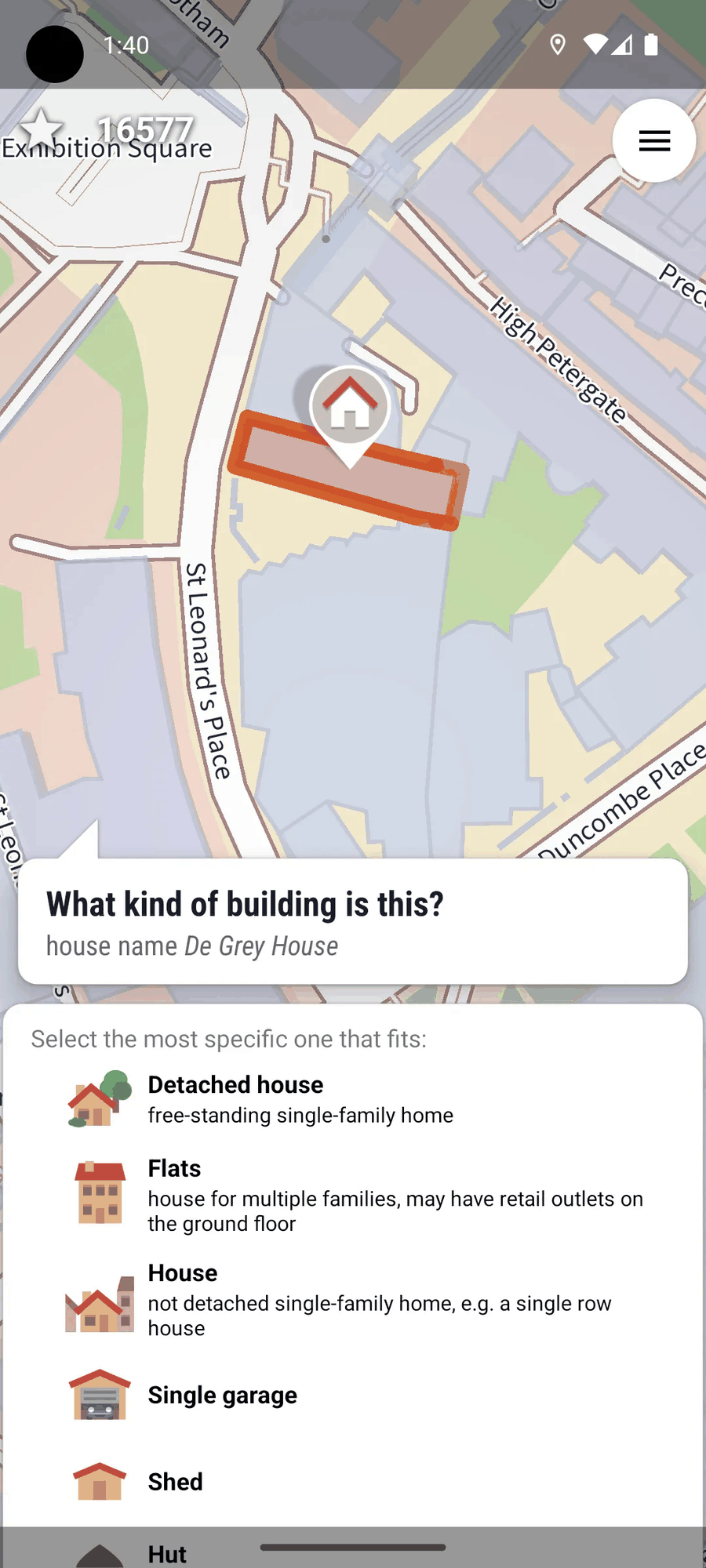 ▲ Each quest is a simple yes/no or multiple-choice question — answer on the spot with a glance, no expertise needed (source: streetcomplete.app)
This design is addictive precisely because it doesn’t feel like a task. It sits at a subtle psychological sweet spot: the difficulty is low enough that it requires zero willpower to start (no need to “psych yourself up”), yet it’s real enough — you’re genuinely changing a map used by millions of people worldwide, not filling a virtual progress bar in some game. As HN user preetham_rangu wrote: “I use this app while walking my dog, and now my biggest motivation is literally ‘wait, does that trash can have a lid or not?’”
Another user, wafflemaker, shared a story: while traveling with friends in the Norwegian mountains, they noticed OpenStreetMap showing a hiking trail that didn’t appear on Google Maps. With a “let’s see what this weird map is talking about” attitude, they followed it — and found a genuine trail winding uphill behind thick forest. After climbing for a few minutes, passing a small cabin with no road access, they reached a large rock overlooking a fjord — a spectacular viewpoint unmarked by any travel guide. “It was a really lovely holiday memory,” they wrote, “all because someone had marked that little path on OSM.”
Enter the Antagonist: Why Google Maps Should Be “Worried”
At this point, the StreetComplete story is heartwarming enough — a programmer, a community, a bunch of people fixing maps while walking their dogs. But if it stopped there, this article wouldn’t have scored 662 points on HN.
What truly ignited the programmer community was the invisible narrative axis running beneath StreetComplete: community-driven vs. corporate monopoly, open data vs. walled gardens, real human contributions vs. AI-generated fuzzy information. These three oppositions strike directly at the two most sensitive nerves in the programmer psyche — the ideal of “decentralization,” and the anxiety around the “AI bubble.”
Let’s start with the state of the mapping industry. Google Maps and Apple Maps are the navigation tools used by the vast majority of people. How they operate: the company invests enormous sums to collect data (satellites, Street View cars, commercial partnerships), the data is the company’s private property, and users are data consumers — you can use it, but you can’t change it. If something on the map is wrong, the most you can do is “submit feedback,” and whether that feedback actually gets adopted — or when — is anyone’s guess. As one HN user put it with surgical precision: “The ‘report an error’ button on Google Maps is functionally a prayer device.”
OSM takes the exact opposite path: data is a public good, and users are co-producers of that data. Spot an error? You can fix it yourself — and with tools like StreetComplete, the barrier to entry is near-zero. Fix it, and it takes effect immediately. This path has already been proven once by Wikipedia — fifteen years ago, nobody believed a group of volunteers could compile an encyclopedia more comprehensive and more current than the Encyclopædia Britannica. Today, Wikipedia is one of the top ten most-visited websites on the planet. The “Wikipedia moment” for map data may be happening right now.
Then layer on the second element: StreetComplete covers dozens of detailed data types — road surfaces, sidewalks, streetlights, trash cans, benches, drinking fountains, store names, speed limit signs, accessibility features — that are precisely the “last mile” data that satellites and Street View cars struggle most to reach, and that AI finds hardest to infer from raw pixels. AI can guess whether a road has a sidewalk (based on pixel patterns in satellite imagery), but it can’t guess whether a tiny shop is still open for lunch today. A resident walking their dog, on this front, absolutely crushes every large model.
And the third layer — the one I find most powerful: StreetComplete transforms “public-good contribution” from a heavy moral obligation into a light, everyday pleasure. It doesn’t ask you to “join an organization,” “meet a group of people,” “learn a skill set,” or “commit a block of time.” You just answer three quick questions on your way home from work — and your city becomes a little more complete on a map the whole world can see.
The Cultural Code Behind 662 Points: Why Programmers Got Emotional
Back to Hacker News. Why did a map-fixing app claim the day’s top spot in a community whose lifeblood is AI, cryptocurrency, programming languages, and startup fundraising?
My read: StreetComplete is an extreme specimen of “technical goodwill.” In a year saturated with AGI anxiety, layoff news, Big Tech monopolization, and AI-generated disinformation, StreetComplete offered a rare contrast — an independent developer, using the simplest possible design, solving a real, concrete problem. No funding announcement, no growth hacking, no “disrupting the industry” slide deck. The project homepage’s first sentence is simply: “Help improve OpenStreetMap with StreetComplete!”
HN users noted that the app runs under a banner warning that “Android is becoming a closed platform” — which is itself a statement of values. Another user, westnordost (yes, the developer himself), patiently answered over a dozen technical questions in the comments: why a native app rather than a web version (because it needs to work offline, with data stored in SQLite), the status of the iOS port (being migrated using Kotlin Multiplatform), why certain quest types sometimes repeat (community tagging conventions are still evolving).
These details showed programmers someone who cares about code quality, about user experience, about community consensus — maintaining something he genuinely believes matters. In the cold ecosystem of an anonymous forum, that kind of warmth is rare.
There’s a hidden resonance too: in the programmer worldview, “open data” is fundamentally about power allocation. Whoever owns the map data owns the power to decide “what exists and what doesn’t.” Google Maps can decide a small alley isn’t worth including, can decide a neighborhood’s business listings aren’t worth updating. When that power is distributed among every ordinary person willing to glance up from their phone for an extra moment, the map ceases to be a company’s product and becomes public infrastructure.
Epilogue: Next Time You Go Out, What’s Your City Still Missing?
StreetComplete is currently Android-only (an iOS port is in development), translated into over 50 languages including Chinese. After writing this article, I glanced at its GitHub repository — an active issues section, users in dozens of languages submitting translations and improvement suggestions, a community atmosphere that’s warm and pragmatic.
This app won’t replace Google Maps. What it addresses is the question of “who ensures the existence of all those things between point A and point B that we take for granted” — is this sidewalk cracked? Is this intersection wheelchair-friendly? Does this bus stop have shelter from the rain?
Next time you head out, maybe pause and consider: the road you walk every day — is it, in the map database, a fully detailed space with every feature carefully annotated, or just a gray outline with lane markings? The gap between those two states is filled, one by one, by people willing to stand on the sidewalk for five seconds and move a finger.
Reference links: