
Exploding into Category 5: AI Mastered the Path but Missed the Surge
In late September 2026, coastal residents closely tracked Hurricane Polo on weather apps. Across digital forecast interfaces, artificial intelligence weather models performed remarkably well. Trained on computational algorithms and historical meteorological records, these systems mapped the storm’s trajectory from the Pacific toward the Mexican coast with pinpoint precision. Yet on September 21, Polo—originally an ordinary tropical storm—abruptly surged within 24 hours to sustained winds of 290 km/h (180 mph), exploding into a catastrophic Category 5 hurricane.
Sustained winds of 290 km/h deliver force comparable to the headwind of a high-speed bullet train operating at top velocity. Meteorologists classify any storm whose wind speeds jump by at least 35 km/h in a 24-hour window as undergoing rapid intensification. This surge occurs when thermodynamic and dynamic atmospheric conditions align in rare synergy, driving a storm’s destructive energy straight up. Faced with Polo’s violent escalation, neither modern AI models nor traditional dynamical forecast systems—which calculate atmospheric dynamics via fundamental physical equations—issued timely warnings.
History has repeatedly witnessed similarly destructive surges. In 2018, Hurricane Michael rapidly intensified into a Category 5 monster as it neared the Florida coastline, leaving local communities virtually no time to evacuate. In recent years, artificial intelligence has advanced rapidly, matching decades of progress achieved by numerical weather prediction systems. Algorithms now deliver remarkable gains in predicting where a storm is headed. Yet when forecasting how fierce a hurricane will become, algorithms still repeatedly stumble.
Sparse Oceans and Missing Depths: The 3D Data Gap
Predicting where a storm goes and predicting how strong it gets are fundamentally different challenges. Global storm tracks are largely governed by large-scale atmospheric steering currents. Decades of atmospheric observations provide ample data to train precise path-prediction algorithms. Determining whether a storm will suddenly explode into a monster, however, demands high-resolution three-dimensional structural data from deep within the cyclone itself.
In the real world, data of this quality is exceptionally scarce. Hurricanes are most prone to rapid intensification over deep open oceans, far from continental landmasses. Weather stations, coastal radars, and oceanic buoys are clustered near shorelines; vast expanses of the open ocean host only sparse observational instruments—the equivalent of dropping a few scattered message bottles across thousands of square kilometers of open sea. While weather satellites gaze down at cloud formations from orbit, they cannot simultaneously capture the internal three-dimensional thermodynamic details of every hurricane across the planet.
To bridge this observational gap, researchers have attempted to generate synthetic training data using numerical model simulations—computing atmospheric changes through physical equations. Yet numerical simulations inevitably rely on approximations and computational simplifications, failing to faithfully reproduce microscale thermodynamic processes within the storm core. The lack of comprehensive, high-quality 3D training datasets remains the first major bottleneck holding back artificial intelligence.
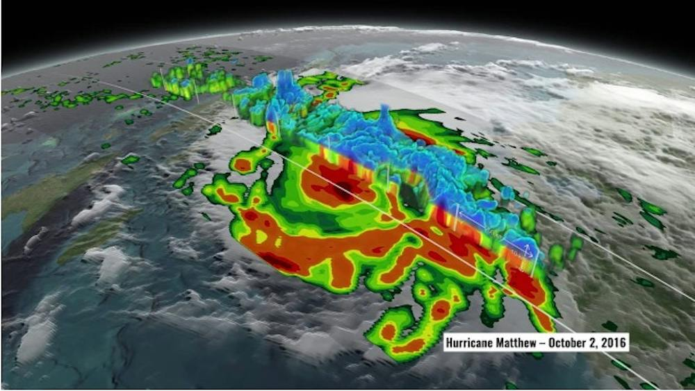 Figure: Visualization of sliced hurricane structure from satellite observations. Source: The Conversation / NASA Scientific Visualization Studio
Atmospheric Chaos: How Tiny Fluctuations Trigger Massive Surges
Beyond data scarcity, a more fundamental bottleneck lies in the underlying physics of atmospheric dynamics. Atmospheric scientist Chanh Kieu of Indiana University published research in the journal Tellus A demonstrating that hurricane intensity evolution is fundamentally governed by chaos. In chaotic systems, minuscule variations in initial states amplify exponentially over time. A fractional shift in ocean temperature or atmospheric air currents can trigger dramatic swings in a storm’s subsequent intensity.
In meteorological physics, warm ocean water serves as the engine fuel, while wind shear acts as the primary brake. Vertical wind shear—the difference in wind speed and direction between low and high altitudes—mechanically tears at the storm’s structure. Higher sea surface temperatures raise the storm’s theoretical potential intensity—the thermodynamic ceiling calculated from water temperature and atmospheric conditions—while simultaneously widening the range of potential internal intensity swings.
Kieu’s research indicates that these intensity fluctuations unfold across a chaotic attractor: the multi-dimensional manifold of potential atmospheric states, analogous to a marble rolling through complex basins on an undulating surface. Along such chaotic trajectories, an initial measurement error as tiny as 0.1 degree Celsius amplifies rapidly over lead time. Empirical verification from the National Hurricane Center (NHC) confirms that hurricane intensity forecast accuracy degrades sharply beyond a few days out.
The Error-Minimization Trap: When Smoothing Algorithms Erase Extreme Gusts
This chaotic reality clashes directly with the foundational training mechanics of artificial intelligence. Mainstream machine learning models are designed to minimize empirical prediction error—adjusting parameters to reduce the mean discrepancy between predicted values and historical outcomes. When confronted with massive datasets, the mathematically safest strategy for an algorithm is to forecast the most probable, average evolutionary trajectory.
When models gravitate toward smoothed average forecasts, rare and violent intensification spikes are routinely filtered out as statistical noise. If a model were optimized to catch every sudden surge, its overall average mathematical error across all historical cases would increase. Minimizing aggregate forecast error and capturing chaotic, low-probability extremes exist in direct mathematical tension.
Here, purely data-driven forecasting hits a structural ceiling. As long as observational data retains measurement uncertainty and the atmosphere remains governed by chaotic dynamics, algorithms pursuing a single deterministic average cannot reliably sound the alarm before a rapid explosion. Throwing more compute power and historical datasets at the problem cannot overcome the intrinsic limits of atmospheric physics.
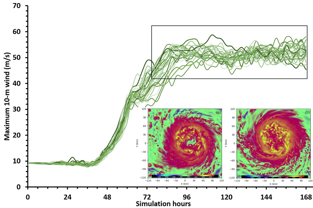 Figure: Forecast divergence on hurricane intensity between AI and dynamical models widens with longer lead times. Source: The Conversation / Chanh Kieu
Beyond Deterministic Numbers: Forecasting Shifts Toward Probability
Confronted with the reality of chaotic systems, meteorological forecasting is undergoing a paradigm shift. Next-generation systems are moving away from providing single deterministic figures—such as “maximum sustained winds of 160 km/h”—and transitioning toward probabilistic ranges and probability distributions. Probabilistic forecasting gives disaster response authorities early visibility into the risk of rapid intensification, even when its exact timing remains uncertain.
For coastal residents, grasping this transition is vital. When meteorologists issue hurricane warnings, probabilistic ranges serve as a reminder not to fixate solely on the median forecast number, but to maintain sufficient safety margins for unexpected, violent escalation. Acknowledging the limits of predictability is itself a cornerstone of disaster resilience.
Artificial intelligence has fundamentally transformed how humanity tracks global weather patterns. Yet when facing the explosive fury of hurricane intensity, purely data-driven models reveal unmistakable boundaries. Rapid intensification remains ruled by chaotic physical processes, while loss-minimizing algorithms naturally smooth out violent extremes. When untamed energy gathers over distant ocean waters, nature reminds us that atmospheric forecasting must always remain grounded in reverence for the laws of physics.
References:
- The Conversation Report
- Tellus A Research Paper