On the morning of October 25, 2026, residents across Scotland woke to howls outside their windows. Stepping into kitchens to flick on the kettle, they found no power indicator lights. Whole streets saw electric radiators and heating shut down. Opening back doors, fallen mature oaks blocked roads, dragging down overhead power lines across the asphalt.
Emergency phone alerts flashed a single recurring name: Storm Boelo. In Castle Douglas, southern Scotland, a man died after being struck by a falling tree. By 3:00 PM that afternoon, over 160,000 households across the UK had lost electricity.
Just two days earlier, Storm Austen had swept through the country. The back-to-back storms left a cumulative 830,000 homes temporarily without power. Instead of bombarding the public with dry barometric pressure readings, the Met Office assigned an official human name to the gale: Boelo.
85 mph Winds Rip Down the Grid as Scotland Takes Half a Month of Rain Overnight
The storm’s destructive force showed up immediately on anemometers. At Machrihanish on the western Scottish coast, peak gusts reached 85 mph (around 137 km/h)—faster than motorway speed limits. In exposed terrain, pedestrians could barely keep their footing.
The electrical grid buckled rapidly. Energy Networks Association figures showed 161,000 homes plunged into darkness on Sunday—an outage scale equivalent to cutting power to the entire city of Cambridge. Home heating ceased, and food in freezers began thawing.
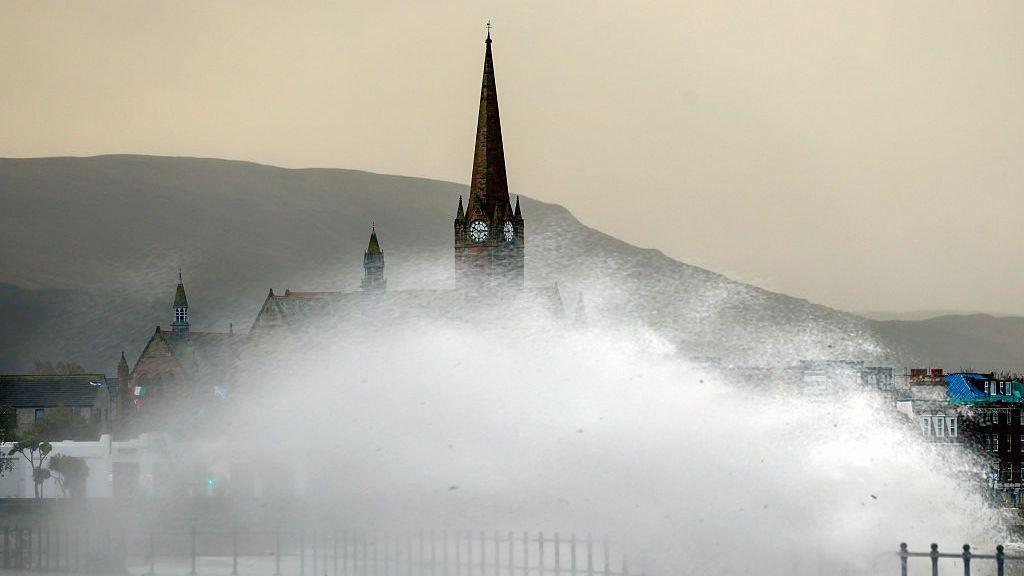 Photo: UK street scene during stormy weather. Source: BBC News
Torrential downpours followed immediately. Cluanie Inn in the Scottish Highlands recorded 130 mm of rainfall—roughly half a month’s precipitation dumped in little over a dozen hours. The Scottish Environment Protection Agency issued 17 flood warnings, while the Met Office delivered an unequivocal advisory: “Stay indoors wherever possible and avoid walking near buildings or large trees.”
No Fixed Wind Speed Threshold: Impact Trumps Raw Numbers
Many assume weather agencies rely on rigid wind speed thresholds before naming a storm. The Met Office’s operating framework deliberately departs from that intuition. There is no arbitrary wind baseline; the deciding factor is the anticipated severity of impact and disruption.
The tiered warning system reflects concrete operational thresholds. Amber warnings—signaling severe likelihood of power cuts, travel disruption, and damage—serve as the core trigger. Once an Amber alert is hoisted, significant damage is practically assured. A Red warning, the highest tier, denotes a threat to life and calls for immediate shelter-in-place precautions.
Extratropical cyclones hit differently across seasons. In late October, broadleaf trees still retain dense canopies, functioning effectively like hoisted sails in high winds. The exact same gale that whistles harmlessly through bare winter branches will rip entire root balls and overhead lines straight out of the ground in October.
Days prior, when Storm Austen was initially designated, forecasters held it at a Yellow warning (minor travel inconvenience). Yet meteorologists recognized that saturated ground would dramatically lower tree stability against subsequent gusts, prompting them to launch the naming process ahead of a formal upgrade.
Alphabetical Rotations: How Three Weather Services Locked Out Chaos
Assigning human names to windstorms is a relatively recent convention. Before 2015, Western Europe lacked coordinated meteorological messaging. German meteorologists used their own nomenclature, Irish broadcasters followed local conventions, and British tabloids invented sensationalist headlines.
Conflicting names over the airwaves left the public uncertain whether incoming winds posed real peril. Confusing messaging cost critical preparation time. To eliminate conflicting storm labels, the UK Met Office partnered with Ireland’s Met Éireann in 2015 to establish a shared naming protocol, later joined by the Royal Netherlands Meteorological Institute (KNMI).
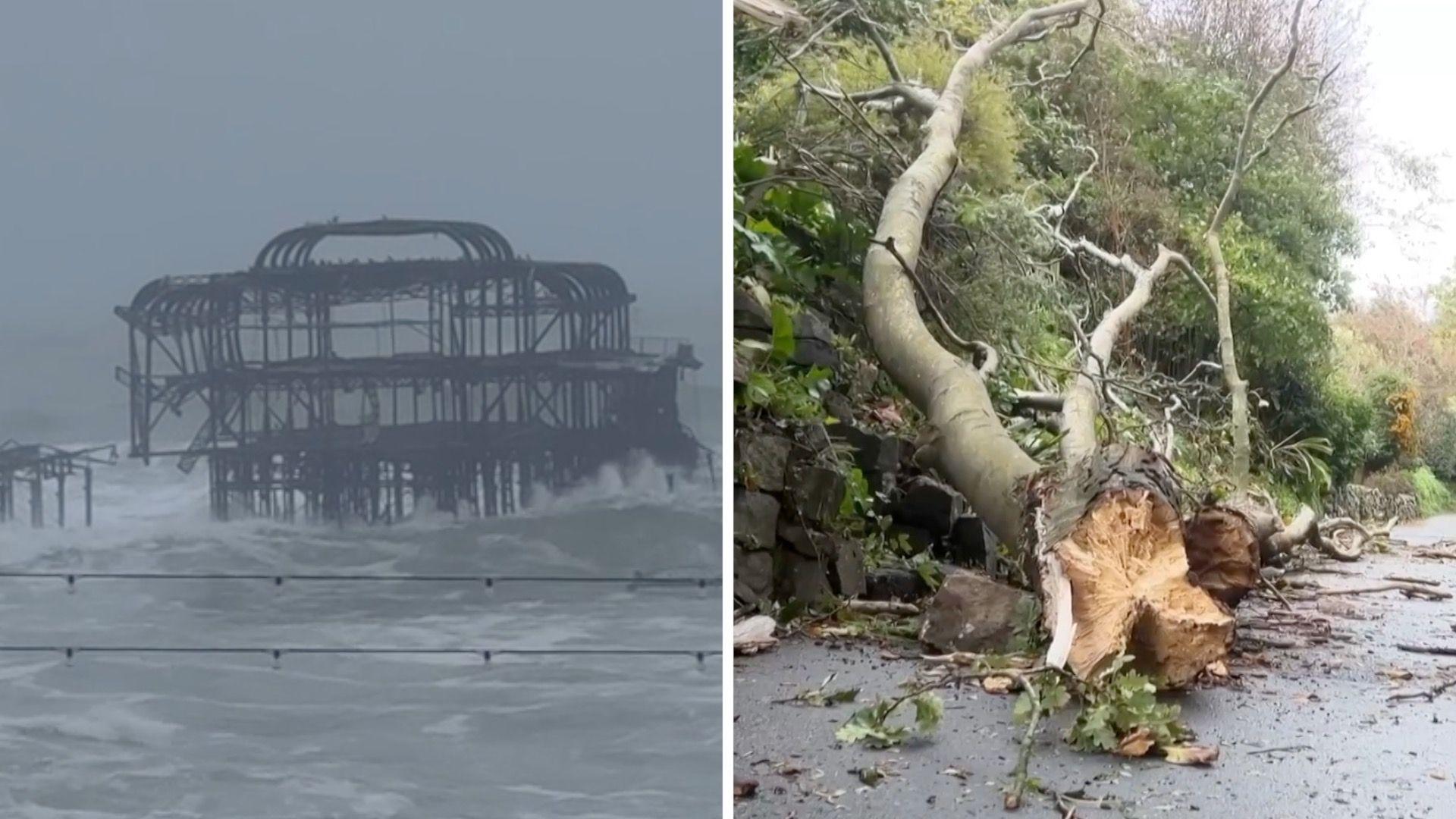 Photo: Scene of storm aftermath. Source: BBC News
Every September, the three agencies jointly release a fresh roster running alphabetically from A through Z. This season opened with Austen, immediately followed by Boelo. The public submits candidate names, which meteorological panels review and finalize.
Strict guidelines govern the list. Letters Q, U, X, Y, and Z are excluded to align with US National Hurricane Center conventions, as few common European first names begin with those letters. Commercial brand names and living public figures are strictly barred to ensure warning messages retain absolute impartiality.
Climate Change May Not Spawn More Storms, but Sea Levels Raise the Damage Ceiling
When severe gales hit, public discourse often reflexively attributes them to climate warming. Long-term empirical records paint a more nuanced picture. The Met Office notes there is no conclusive evidence showing that the total frequency of mid-latitude storms is rising or falling; natural year-to-year variability remains dominant.
Yet while storm counts remain steady, their destructive capacity is quietly climbing. For every 1°C increase in global average temperature, the atmosphere can hold approximately 7% more water vapor. When a low-pressure vortex tracks across warming seas, it pulls in substantially greater moisture volumes, unleashing catastrophic inland rainfall.
Sea-level rise exerts relentless pressure on coastal infrastructure. Storm surges—extreme sea levels forced ashore by gale-force winds and low atmospheric pressure—now ride atop elevated baseline sea levels, overtopping sea walls with greater ease. Coastal defenses engineered decades ago struggle to contain surges riding higher baselines.
Large-scale climate oscillations compound the threat. In August 2026, The Guardian cited Met Office analyses warning that one of the century’s strongest El Niño cycles had redirected North Atlantic jet stream patterns. A persistent atmospheric river aimed directly at Western Europe, steering multiple vigorous cyclones into the British coastline in rapid succession.
Turning Warnings into Reflexes: Putting Names Ahead of the Gale
Naming an invisible low-pressure vortex “Boelo” fundamentally serves public psychology and risk communication. As the Met Office highlights, when forecasters, news media, and emergency responders rally around a single shared name, communities instantly grasp the severity of the hazard.
Ordinary households cannot parse isobaric weather charts or commit barometric readings to memory. But once radio bulletins and smartphone push notifications uniformly alert everyone to Storm Boelo, mutual awareness crystallizes instantly. Ferry terminals halt sailings, construction sites brace scaffolding, and homeowners secure garden furniture before winds hit.
By giving storms names, meteorological services turn public memory into a defensive shield. Raw atmospheric variables on paper cannot stop falling trees, but concrete names drive decisive action before roofs are torn away. When 85 mph gales approach, effective protection means staying a step ahead of the storm.
Reference Links:
- BBC News on-the-ground coverage of Storm Boelo damaging the UK power grid
- The Guardian comprehensive report on Storm Boelo warnings and Scottish casualties
- UK Met Office official guidance on storm naming criteria and standards
- The Guardian meteorological analysis on century-strength El Niño intensifying UK autumn storms