
Winds Surge to 180 mph in 24 Hours: The Night AI Forecasts Failed
On September 21, 2026, residents along Mexico’s Pacific coastline received emergency weather alerts on their phones. Hurricane Polo, initially projected as a modest tropical storm (a low-pressure rotating cyclone fueled by ocean evaporation), underwent a staggering transformation just offshore. Within 24 hours, its maximum sustained winds exploded to 180 mph (290 km/h).
That wind speed matches the cruising speed of high-speed passenger rail, unfolding directly in the sky. Leaping through multiple storm categories, Polo rapidly swelled into a catastrophic Category 5 hurricane—one of the fiercest Pacific storms observed in decades.
To many, weather forecasting appeared to have entered an infallible AI era. In recent months, atmospheric models developed by Google DeepMind and other teams set new accuracy records for typhoon and hurricane tracks, pinning down landfall coordinates days ahead of time. Yet as Polo intensified before their eyes, state-of-the-art AI models failed to provide timely warnings about its peak fury. Such blind spots are painfully familiar: in 2018, Hurricane Michael rapidly intensified just hours before slamming into the Florida Panhandle, leaving coastal communities virtually no time to evacuate.
Data Gaps in the Open Ocean: Why AI Struggles with Fine-Scale Physics
Why can AI pinpoint where a storm will make landfall, but stumble so badly when estimating how strong it will become? The answer lies in the fundamental physics across spatial scales.
A hurricane’s path is steered by atmospheric circulation patterns spanning thousands of kilometers—much like a powerful river current carrying a boat. Modern satellites easily track these macro-scale flows. Storm intensity, by contrast, is dictated by fine-scale dynamics within a 50-kilometer radius around the eye, governed by fierce convection towers and turbulent heat exchanges deep inside the eyewall clouds.
Humanity’s dense networks of weather stations, Doppler radars, and ocean buoys are overwhelmingly clustered along coastal waters. The most pivotal phases of hurricane intensification occur over the open ocean, where in-situ measurements are exceedingly sparse. Even advanced satellites face geometric and spectral constraints; they cannot provide a continuous, high-resolution three-dimensional CT scan of every storm’s internal structure.
Turning to numerical simulation datasets generated by physics-based models—computer programs solving fluid dynamics and thermodynamics equations—does not eliminate the problem. Simulations inevitably rely on mathematical approximations and parameterizations that smooth over microphysical details. Deprived of comprehensive 3D observational datasets, training AI models on storm intensity remains an exercise in piecing together shadows.
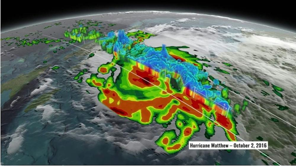 Figure: Intensity profile of 2016 Hurricane Matthew created from satellite observations. Source: The Conversation / NASA Scientific Visualization Studio
The Butterfly Effect in the Atmosphere: The Intrinsic Chaos of Storm Intensity
Beyond data scarcity, fundamental physical laws constrain machine learning. Decades ago, MIT atmospheric scientist Kerry Emanuel formulated the potential intensity theory: sea surface temperatures set the theoretical thermodynamic speed limit for a cyclone in a given atmospheric environment. Whether a storm actually approaches that theoretical ceiling, however, depends entirely on chaotic internal dynamics.
Recent investigations led by Indiana University atmospheric scientist Chanh Kieu demonstrate that hurricane intensity evolution exhibits irreducible chaotic properties. It resembles rolling a snowball down a jagged mountain peak: a shift in starting position of just a single millimeter can send the snowball hundreds of meters off course at the base.
Crucially, research indicates that intensity fluctuations occur inside what mathematicians call a chaotic attractor—a bounded geometrical manifold where the storm’s state wanders unpredictably among countless possible trajectories. Microscopic measurement errors in atmospheric pressure or humidity amplify exponentially over time. Even if scientists could deploy sensors to record the complete atmospheric state of every storm every second, a deterministic, single-number wind speed forecast over longer lead times remains physically impossible.
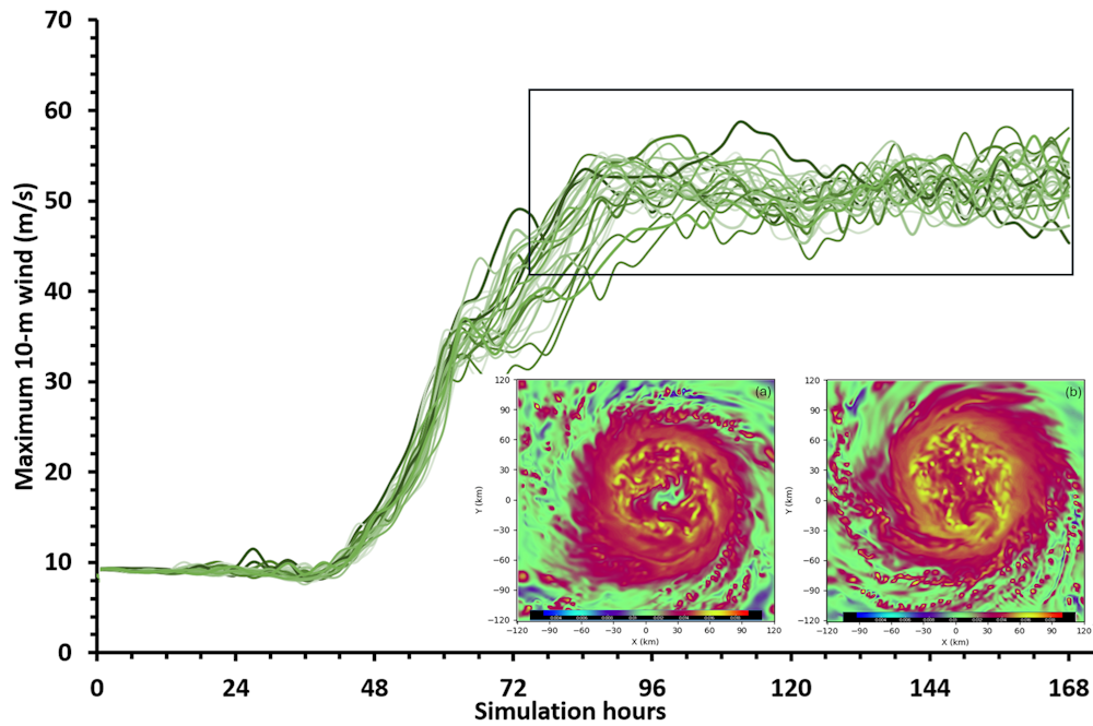 Figure: Computer simulations show that model divergence on hurricane intensity widens dramatically as forecast lead times increase. Source: The Conversation / Chanh Kieu
Chasing Minimal Error Flattens the Extremes: The AI Training Dilemma
Today’s machine learning architectures are typically trained to minimize loss functions, such as mean squared prediction error. Yet when confronted with deeply chaotic dynamics, algorithms learn that predicting a smoothed average is the safest way to avoid large mathematical penalties.
This creates an irreconcilable structural tension. If an algorithm ruthlessly minimizes average error, it systematically erases rare, catastrophic surges in wind speed. Conversely, if an AI is optimized to capture volatile chaotic fluctuations, its average point prediction error cannot be reduced indefinitely. These two objectives directly compete with one another, forming the mathematical bottleneck of existing meteorological AI.
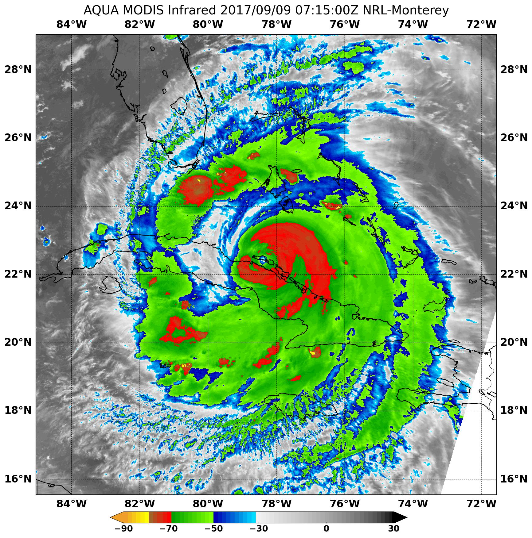 Figure: Satellite imagery of Hurricane Irma in 2017. Source: NASA
Moving Beyond Single Numbers: Preparing for Storms with Probabilities
The failure of AI models to anticipate explosive hurricane intensification demonstrates that pure machine learning cannot replace physical principles. Deep learning depends on historical observations, but the atmosphere’s fine-scale dynamics contain irreducible chaos. Here, purely data-driven models collide with a physical ceiling.
To safeguard vulnerable populations, weather forecasting must transition away from pinpoint deterministic numbers and toward comprehensive probabilistic ensembles. When a tropical cyclone approaches, the public should not obsess over whether the forecast says 100 mph or 130 mph. Evaluating the probability distribution of rapid intensification risks is the only rational way to prepare for nature’s most volatile storms.
Reference Links:
- The Conversation Coverage