
In August 2026, Google DeepMind published a paper in Nature: AI-driven tropical cyclone forecasting is now demonstrably more accurate than traditional physics-based models. The figures are concrete—WeatherNext achieves a 3-day forecasting accuracy equivalent to the 2-day benchmark of legacy systems. In practical terms, forecasters have gained a precious 24-hour lead time out of thin air.
This leap forward is substantial. DeepMind estimates it compresses a decade of meteorology progress into a single step. Over the past 50 years, tropical cyclones have claimed over 700,000 lives and caused $1.4 trillion in economic damage globally. Whether called typhoons, hurricanes, or cyclones, they describe the same phenomenon—massive, spinning storms born over oceans that sweep toward land. Every additional hour of advance warning means more lives saved through timely evacuation.
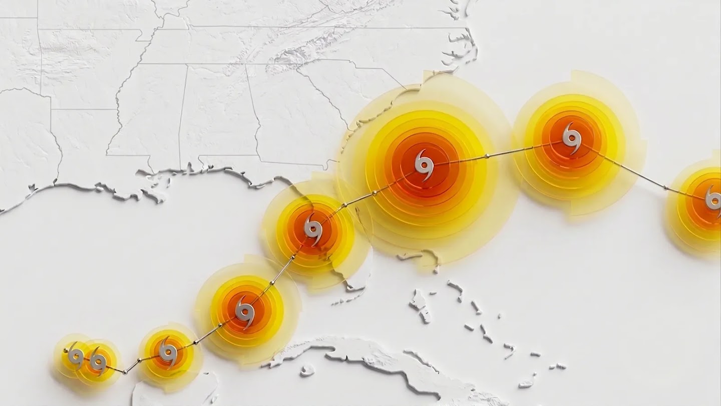
Figure: WeatherNext forecasted track and intensity schematic, with concentric circles depicting different wind speed thresholds. Source: deepmind.google
Traditional Forecasting: Physics Lessons inside Supercomputers
To appreciate this milestone, consider how weather forecasting has worked for over a century: by solving physical equations on supercomputers. The Earth’s atmosphere is discretized into a dense 3D grid, where temperature, pressure, and wind vectors at every node are computed step-by-step using Newton’s laws and thermodynamics.
This approach is notoriously slow and computationally expensive. Global models run at coarse spatial resolutions because a single forecast consumes immense supercomputing resources. Raising the resolution to capture fine typhoon structures inflates compute costs exponentially. Meteorologists are caught in a dilemma: a cyclone’s overall track is driven by large-scale steering flows spanning thousands of kilometers—ideal for coarse global models—while its intensity is dictated by localized thermodynamic processes near the eye wall, requiring hyper-local high-resolution models. Traditional forecasting has long been forced to compromise between the two.
AI Forecasting: A Veteran Forecaster Reading 40 Years of Weather
WeatherNext takes an entirely different route. Bypassing physical equations altogether, it learns empirical patterns directly from historical climate data. Its training dataset comprises nearly 20TB of global atmospheric reanalysis alongside detailed records of nearly 5,000 historical storms from the International Best Track Archive for Climate Stewardship (IBTrACS). In essence, AI was fed 40 years of Earth’s atmospheric history, encoding the mechanics of cyclone genesis, trajectory shifts, and rapid intensification into its neural model parameters.
Given current weather conditions as input, WeatherNext generates a 15-day global forecast in under a minute. Think of it like cooking: traditional forecasting measures every gram of flour from scratch every time, whereas AI has memorized 40 years of recipes and can instantly draft a menu just by looking into the fridge.
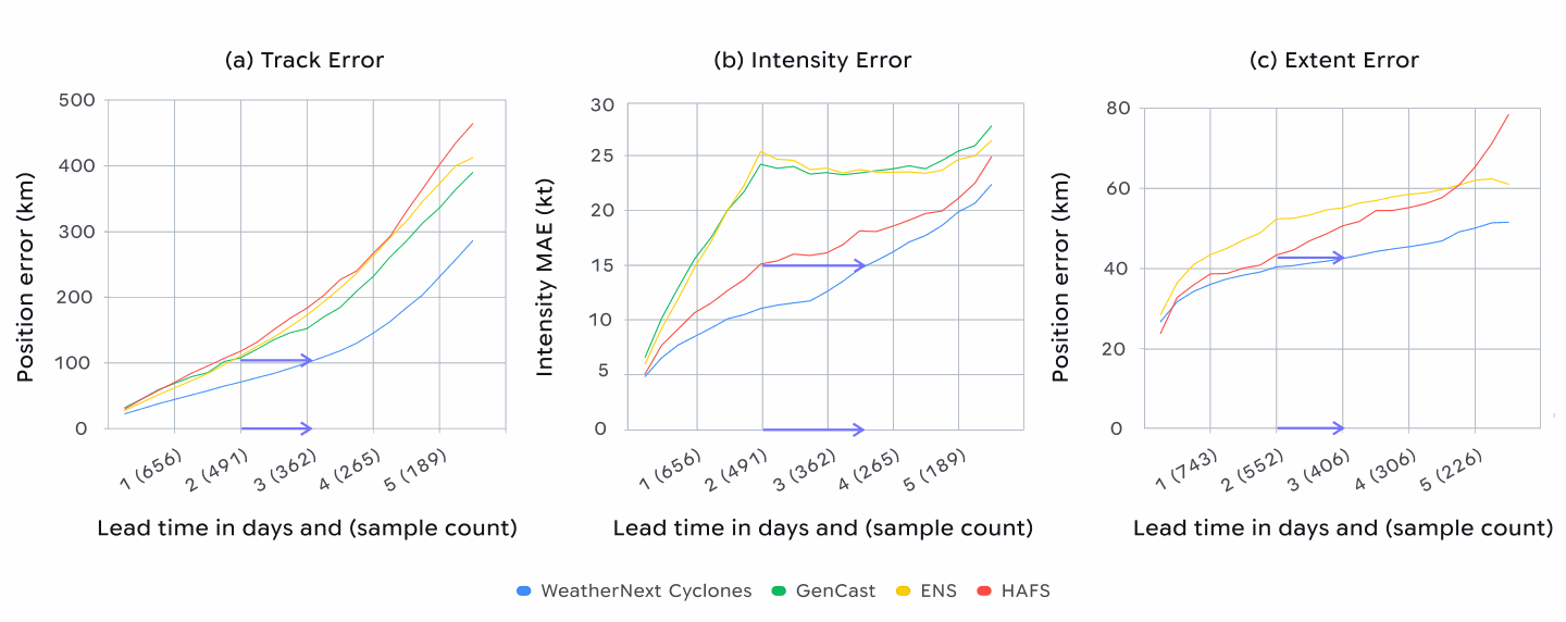
Figure: Comparison of track, intensity, and wind radius errors over a 5-day forecast window. The blue line represents WeatherNext, achieving the lowest overall error and highlighting an approximate 1-day accuracy lead. Source: deepmind.google
Where the Breakthrough Lies: Three Key Numbers
Gaining a full day. Achieving 3-day forecast accuracy comparable to the previous 2-day standard effectively shifts advance warning times forward by 24 hours. From an engineering perspective: for coastal residents, those 24 hours mean reinforcing windows, gathering essentials, and evacuating safely; for meteorologists, it provides the confidence needed to issue top-tier hurricane alerts.
Smaller errors. Averaged across 2023 to 2025, WeatherNext reduced 3-day track error by approximately 100 kilometers compared to ECMWF ensemble forecasts, while intensity error was about 11 knots (~20 km/h) lower than specialized hurricane models. In practical terms: a 100 km track error is the difference between flooding one city versus another; an 11-knot intensity difference dictates whether residential roofs hold up against the gale.
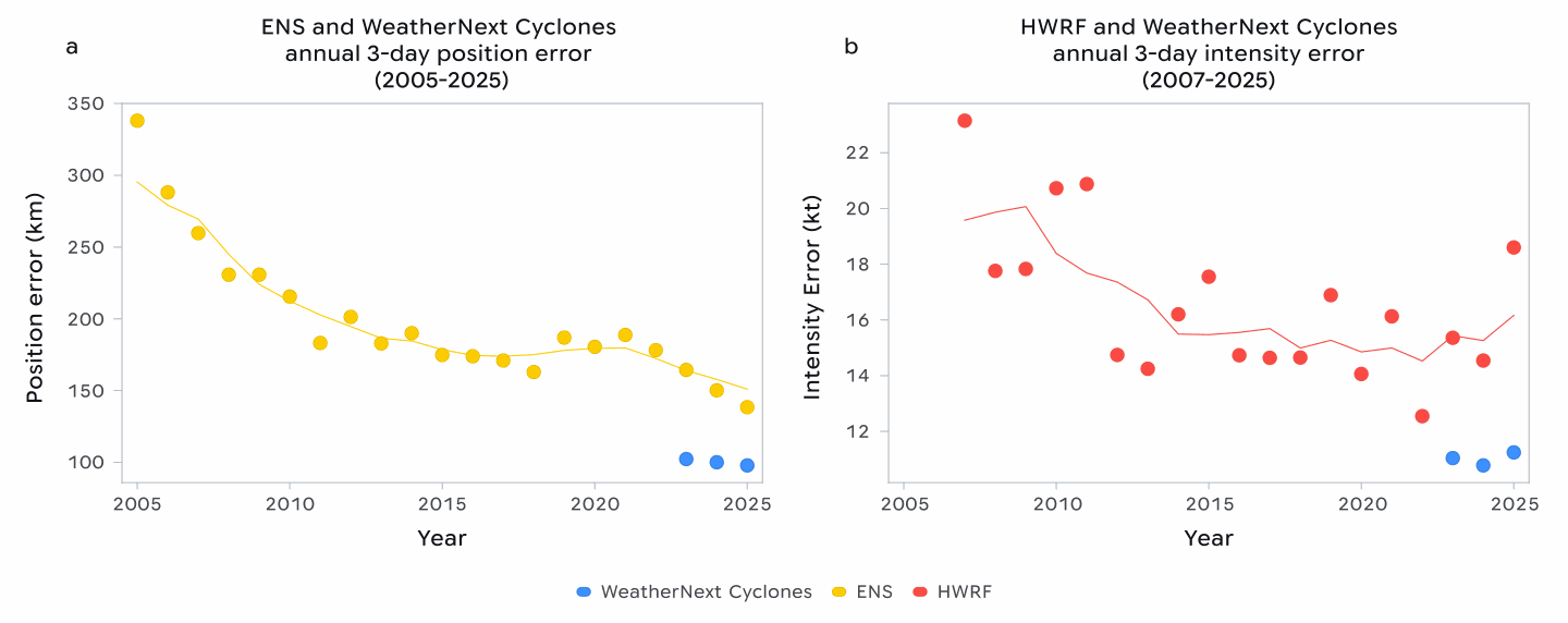
Figure: Year-by-year 3-day forecast errors from 2023 to 2025. Blue indicates WeatherNext, showing ~100 km lower track error and ~11 knots lower intensity error. Source: deepmind.google
Broader probabilistic coverage. Where traditional operational runs generate dozens of ensemble members, WeatherNext expanded its ensemble size to 1,000 members, explicitly targeting low-probability, high-consequence scenarios such as “rapid intensification.” Rapid intensification is historically the toughest problem in cyclone prediction. In 2025, Hurricane Melissa’s sudden surge before landfall in Jamaica was anticipated in advance, allowing the US National Hurricane Center to issue early alerts.
Surprisingly, WeatherNext achieves these results using data at a 28×28 km grid resolution—100 times coarser than state-of-the-art numerical models. The paper’s authors frankly note in their announcement that why coarse resolution performs so well “remains an open question.” If coarse inputs suffice, compute requirements plummet, enabling weather agencies in developing nations with modest budgets to run world-class forecasts.
Don’t Ignore the Limitations
Community discussions have raised valid concerns. On Hacker News, the announcement post garnered over 300 points and hundreds of comments, with key debates focusing on the scarcity of extreme events in training data. While 5000 historical storms sound extensive, tropical cyclones exhibit heavy-tailed distributions—once-in-a-century extreme events may not appear even once across 40 years of data. Skeptics worry AI might confidently hallucinate when encountering unseen extremes, while proponents point out that traditional physical models also struggle with extreme outliers, whereas AI at least exposes uncertainty through 1000 ensemble trajectories. Both perspectives have merit, and the debate remains unsettled.
Interpretability presents another hurdle. Why 28 km resolution yields superior forecasts is something the authors admit they cannot fully explain. Meteorologists rely on physical mechanisms to explain forecast outputs, which purely data-driven AI models cannot provide. Consequently, public details indicate that current operational workflows deploy AI models alongside traditional systems for cross-validation, with DeepMind stressing that final decision-making remains squarely with human meteorologists. To foster broader adoption, DeepMind open-sourced code and model weights, alongside a lightweight 111 km resolution version that runs on a single TPU or within a free Colab notebook.
Concluding Thoughts
Looking at these figures, the extra 24 hours stand out most. When a cyclone approaches, an additional day of advance warning gives coastal fishing villages vital time to secure boats and evacuate residents.
A century-old discipline is being quietly reshaped by AI. The trajectory of this shift is straightforward: giving ordinary people earlier notice when the storm approaches. How AI performs against novel extreme events will require time to test, but relying on human forecasters and AI working in tandem offers a far stronger defense than either alone.
Reference Links:
- Google DeepMind: WeatherNext AI model achieves breakthrough in forecasting cyclones
- HN Discussion (item?id=49220126)


