An Unconventional Alternative to Reverse Image Search
OSINT security expert Sofia Santos published a drone aerial photograph of a beach resort, challenging solver communities to identify the resort name, island coordinates, and camera orientation. The photo contained no GPS coordinates, camera model metadata, or EXIF information—showing only palm trees, white sand, and three distant landmasses across the water.
Most participants’ immediate reaction was to launch reverse image search engines, attempting to recognize the resort buildings or beach structures. Developer yassa9 chose a completely different approach: closing the search bar, writing a dedicated algorithmic pipeline, and loading 882MB of global coastline vector data directly into GPU VRAM.
In homogeneous natural landscapes, general-purpose vision models frequently fail due to visual feature ambiguity, inducing massive false positives across tropical beaches. Reducing the search problem to deterministic geometry offered the only clear path out of this probabilistic trap.
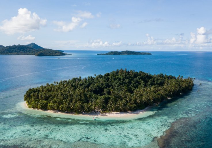 Figure: The OSINT challenge image published by Sofia Santos, featuring three distinct islands. Source: yassa9 blog
Converting Three Island Outlines into a Geometric Fingerprint
Three distinct landmasses are visible in the image frame: the resort island P0 in the foreground, a flat island P1 to the right, and an island P2 with elevation peaks to the left. These three physical points form a specific 2D triangle on the image plane.
The ratios of the triangle’s three side lengths alongside its interior angles form an unforgeable geometric signature. Accounting for perspective distortion and camera lens warping, the algorithm set a ±20% tolerance threshold for this geometric feature set, transforming it into a machine-traversable “geospatial fingerprint.”
The first step in processing was loading OpenStreetMap’s global coastline vector dataset land-polygons-split-4326, with an uncompressed size of 882MB. To avoid a computational explosion, the filtering pipeline applied a multi-stage spatial compression strategy:
Based on tropical vegetation characteristics, the search latitude was constrained between ±30° latitude. The count of surviving land polygons dropped sharply from millions down to 141,131. This initial filter eliminated 68% of global land polygons, bounding the computation strictly within the tropical belt.
Next, a 5km spatial density sampling reduced the node count to 51,576 points. Spatial clustering at a 20km radius grouped these into 23,500 island clusters. Enumerating three-point combinations within each cluster generated 80,690,777 candidate triangles. These 80.69 million candidate combinations converted an intuitive needle-in-a-haystack search into a standardized computational brute-force problem.
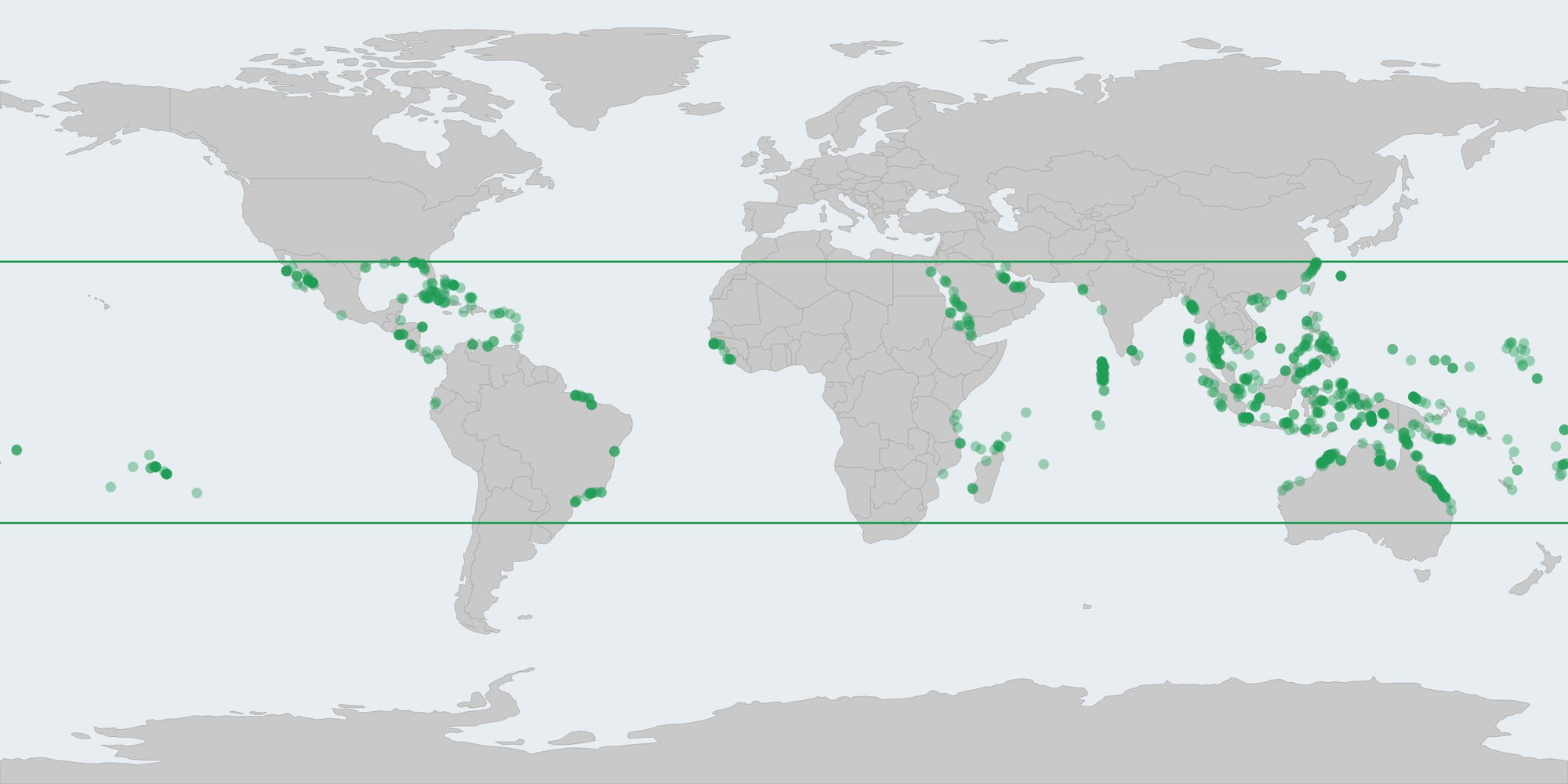 Figure: Candidate location distribution within tolerance boundaries after geometric filtering and CUDA acceleration. Source: yassa9 blog
204 Milliseconds of GPU Brute-Force Matching
Traversing 80.69 million geometric combinations on a conventional CPU would take dozens of minutes, presenting the primary engineering bottleneck. yassa9 wrote a custom CUDA kernel, assigning each candidate triangle matching task to an independent GPU thread.
Executing on an entry-level NVIDIA RTX 3050 graphics card (costing around $150 and using only 5.2GB of VRAM), the CUDA kernel completed all 80.69 million triangle shape match tests in just 204.1 milliseconds. It instantly discarded 99.8% of invalid candidate combinations, preserving 158,784 candidate triangles.
The GPU’s parallel stream processors are exceptionally suited for independent, uncoupled geometric checks; the 0.2-second kernel runtime accelerated the search speed by thousands of times.
A Multi-Layered Data Filtering Pipeline
While 158,784 candidates represented a massive reduction, it remained far beyond human manual verification limits, requiring a multi-dimensional filtering pipeline to prune candidates layer by layer. The pipeline first executed spatial deduplication, merging adjacent duplicate triangles to narrow the surviving count to 8,915 targets.
An open water check followed, removing inland lakes and dense island archipelagos via bounding boxes, leaving 948 nodes. To match the coral reef ring structure visible in the photo, the algorithm introduced the Polsby-Popper compactness metric (calculating perimeter-to-area ratios), further reducing candidates to 213. Compactness filtering successfully stripped away irregular, fragmented coastlines while preserving islands characterized by coral atoll structures.
Subsequent ellipse fill-factor filtering reduced the target set to 137 candidates. The algorithm then integrated satellite remote sensing data, applying the Normalized Difference Vegetation Index (NDVI) with a threshold of 0.6. High vegetation index filtering immediately eliminated bare sandbars and unvegetated artificial structures, bringing surviving candidates down to 66.
The final automated checkpoint leveraged Copernicus DEM 30m elevation data. By comparing the elevation profile of island P2’s peaks seen in the photo, the algorithm required candidate locations to feature mountain structures of specific heights, ultimately isolating just 26 candidate sites. The 30-meter elevation matching eliminated numerous flat coral reefs, delivering the final blow of the automated pipeline.
Human Verification Meets Military-Grade Algorithms
With the automated pipeline compressing 80.69 million options down to 26, the remaining verification was handed to human inspection. yassa9 inspected satellite imagery in order of algorithmic priority and successfully identified the exact match on the 8th candidate point.
The confirmed location was Oan Island in the Federated States of Micronesia (coordinates: 7°21’48.4”N 151°45’20.7”E). The resort in the photo was identified as the Oan Island Resort, captured by the drone camera facing northwest at a bearing of 324.97°.
In Hacker News community discussions, engineers noted that this solution essentially recreated the core principle of TERCOM (Terrain Contour Matching) navigation used in cruise missiles. NASA’s Jet Propulsion Laboratory (JPL) deployed similar geometric feature matching algorithms during the landing of the Mars 2020 Perseverance rover, shrinking the landing ellipse by an order of magnitude.
This personal experiment proved a fundamental engineering reality: whether pinpointing an island from tens of kilometers away or achieving precision landing on Mars, leveraging deterministic geometric constraints to eliminate visual ambiguity is an extraordinarily reliable technical strategy.
Compute Overcoming Intuition
From 882MB of coastline data to a 204-millisecond GPU execution, this experiment in locating an obscure island demonstrates the raw power of modern engineering problem-solving.
The outlines of the three islands in the photograph were, in essence, a geometric signature written onto the surface of the Earth. By converting physical features into computable data structures, vast unknown spaces can be swiftly compressed through sheer compute power.
When GPU brute-force search meets rigorous geometric constraints, traditional human visual recognition—long reliant on experience and luck—is being thoroughly refactored by machine enumeration algorithms.
Reference Links:
- yassa9 blog: Geolocating an Island Photo
- Hacker News Discussion: Geolocating an Island Photo
- gralhix OSINT Challenge: Challenge #004