On October 21, 2026, Mexico’s National Institute of Anthropology and History (INAH) sent an official response. Its national database confirmed that no archaeological remains had ever been registered at the hilltop coordinates in question. The survey report had been submitted by a Google researcher vacationing in South America, who spent 72 hours orchestrating 48 AI agents to pinpoint a millennium-old Maya pyramid directly from open remote-sensing data.
Yet this viral technical marvel took a sharp turn just three weeks later. In a 2025 academic journal paper, professional archaeologists had already meticulously surveyed and mapped the exact same site. What seemed like a breakthrough AI discovery was ultimately confirmed to be an overlap with existing academic work—a classic “rediscovery.”
A Pyramid Found in 72 Hours, Unregistered in Official Records
On October 18, Google researcher Pietro Miotti was traveling in Peru, hearing the storied tale of how explorer Hiram Bingham was guided by local farmers to Machu Picchu. A thought struck him: what would exploration look like if early adventurers had cutting-edge compute at their fingertips? With no formal training in archaeology, Miotti chose the most direct engineering approach to test the idea.
On the night of October 19, 48 AI agents went to work collaboratively in the cloud. Within hours, they sifted through massive image tiles to flag an anomalous elevation. Cross-referencing public archives, the agents determined that the area was almost certainly an uncharted blank spot on official maps. The turnaround of just 72 hours underscored the sheer scanning throughput possible with multi-agent workflows.
On October 20, prompted by model suggestions, Miotti compiled the findings into a Spanish-language dossier and submitted it to INAH. The following day, Mexican officials replied with formal confirmation that no registered archaeological site existed at those coordinates. From submitting the report to receiving official verification, the entire process took a mere 72 hours.
Perched on the edge of a sheer cliff, the complex features an oval pyramid standing 8 to 12 meters high, flanked by a leveled plaza and connected raised courtyards. The architectural layout strongly points to a small administrative center from the Maya Classic period (c. 250–900 CE). A vertical drop of 8 to 12 meters combined with straight edges and right angles—geometry nature rarely produces—was precisely what separated the man-made structure from natural terrain.
Penetrating 17-Meter Canopy: How Lasers Saved Years of Bushwhacking
The greatest barrier to discovering lost civilizations has always been dense tropical jungle. In standard satellite imagery, the canopy forms an impenetrable green blanket, concealing all ground-level features. Early explorers had to mount grueling expeditions, hacking through dense undergrowth with machetes for months just to map a few square kilometers.
Light Detection and Ranging (LiDAR) rewrote the rules of field exploration. When an airborne scanner fires rapid laser pulses toward the ground, most beams bounce off dense foliage. Yet a fraction slips through gaps between leaves, striking the true ground surface and reflecting back to the sensor. The technique functions like a high-precision digital X-ray of the entire jungle.
The sensor collects hundreds of millions of spatial coordinates, assembling a high-resolution 3D point cloud. In forests typically 10 to 17 meters thick, algorithms strip away green foliage points in mid-air and preserve only the brown ground points beneath, digitally deforesting the landscape with a keystroke. Penetrating 10 to 17 meters of jungle canopy in software compressed the immense logistical cost of traditional field expeditions into mere compute time.
Miotti relied on open data from NASA’s Goddard’s LiDAR, Hyperspectral & Thermal (G-LiHT) airborne campaign, which covered roughly 1,200 square kilometers of rainforest. With access to 1,200 square kilometers of public science data, independent explorers no longer need expensive charter flights or specialized flight permits. Open scientific datasets flattened the barrier to entry.
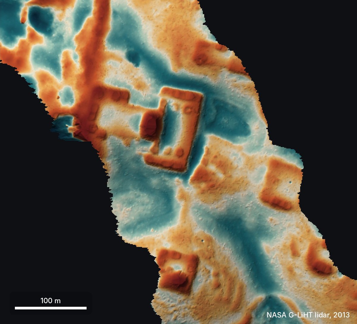 Figure: Bare-earth LiDAR view of the hilltop showing plazas, the pyramid, and terraced platforms after digitally stripping away the forest canopy. Source: Pietro Miotti / pietromiotti.com
48 General Models Splitting the Grid: Nature Rarely Builds in Straight Lines
The search utilized no specialized archaeological models and trained no custom image classifiers. Every task was executed using off-the-shelf multimodal foundation models. Miotti adopted a straightforward engineering playbook: craft crisp visual inspection guidelines for general models, and let parallel compute handle the heavy lifting.
The underlying heuristics rested on plain common sense: nature rarely produces straight lines and right angles. Flowing water carves meandering riverbeds, while wind erosion sculpts smooth curves. Flat rectangular terraces and symmetrical stairways, by contrast, are hallmarks of human construction. Operating like tireless junior research assistants, the 48 agents divided the 1,200-square-kilometer LiDAR dataset into a fine grid, systematically screening out modern roads, sinkholes, and cenotes.
The agents quickly locked onto the hilltop ruins, even outlining three terraced platforms and a flat-bottomed depression—likely an ancient Maya rainwater reservoir (aguada). The models then queried the raw point cloud to verify that the pyramid profile stemmed from solid ground rather than canopy artifacts. Zero custom training paired with spatial point cloud cross-validation eliminated weeks of grueling manual screening.
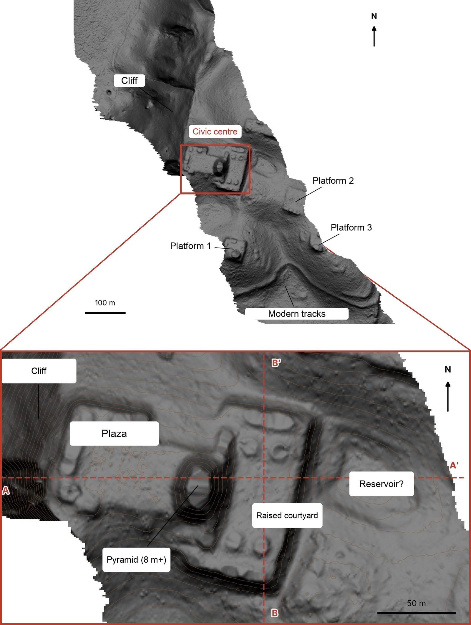 Figure: Top: Bare-earth LiDAR overview of the entire hilltop. Bottom: Close-up of the ceremonial core revealing the plaza, pyramid, and elevated courtyard. Source: Pietro Miotti / pietromiotti.com
The Plot Twist: Accurately Mapped in a 2025 Paper
The technical euphoria was short-lived. On November 11, Miotti posted an erratum at the top of his blog post, conceding that the site had already been documented by scholars. A team led by archaeologist Francisco Estrada-Belli had meticulously mapped the pyramid in a peer-reviewed journal paper published in 2025, with architectural diagrams appearing on pages 13 and 14.
The discrepancy stems from a significant lag between official government registries and research frontiers. Estrada-Belli’s study focused on evaluating regional population density across the Maya lowlands; the hilltop settlement was merely an incidental sample point in their broader dataset. Because formal heritage registration is an administrative hurdle, field discoveries frequently take years to make their way into official state registries.
The 48 agents missed the specialized academic literature during their checks, conflating “unregistered” with “undiscovered.” While the revelation dampened the hype, it also served as an unexpected validation of the technical pipeline. It functioned as a true double-blind test: without expert guidance, an outsider wielding raw compute landed on the exact coordinates previously verified by seasoned scholars.
The Real Shift: The Barrier to Entry Moves to Curiosity and Compute
The revelation ignited heated debate across the tech community. Skeptics criticized the media frenzy, arguing that had a hiker spotted the same ruin on an outdated map, it would never have made headlines; the AI label was the sole catalyst for virality.
Yet professional archaeologists are treading this exact digital path. In 2024, Luke Auld-Thomas and colleagues analyzed open-access LiDAR data to uncover Valeriana, a massive undocumented Maya city. In 2026, Ivan Šprajc identified traces of ancient Maya marketplaces through remote sensing. Academic specialists and tech hobbyists are converging on the same open data infrastructure.
As Miotti reflected in his post-mortem: “I am not an archaeologist, and I didn’t know how difficult this was supposed to be. I took an ancient question and threw compute at it in the most intuitive way possible. In this era, being a naive outsider is turning into an advantage.”
The significance of this experiment is not that machines outsmarted scholars. The agents exhibited no profound reasoning, merely executing geometric rules with fidelity. The true breakthrough lies in the collapse of the trial-and-error barrier. High-resolution open data coupled with affordable compute means access to field discovery is no longer guarded by academia alone. The bottleneck has shifted from decades of credentialed expertise to the curiosity to frame a question and the initiative to orchestrate compute.
References:
- Original post by Pietro Miotti: My AI Agents (Re)discovered a Maya Site in 72 Hours
- Hacker News discussion on the AI Maya site rediscovery
- The Verge coverage: Google researcher uses AI to find Maya ruins
- Estrada-Belli et al. (2025), Journal of Archaeological Science: Reports