
Temperatures Hit +3.05°C on September 19, Topping 2015’s Record Weeks Before the Peak
In late September 2026, travelers planning their autumn getaways began noticing peculiar weather disruptions around the globe. Farmland across India suffered crop losses from deficient monsoon rains. Meanwhile, holiday destinations across the Atlantic experienced an eerie quiet, going deep into autumn without a single hurricane forming. These seemingly disconnected meteorological events share a common origin: unprecedented heat accumulating deep within the Pacific Ocean.
On September 19, 2026, daily sea surface temperature (SST) anomalies across the central-eastern equatorial Pacific hit +3.05°C. A sea surface temperature anomaly measures how much warmer or cooler surface waters are compared to long-term historical averages. This milestone surpassed the previous record of 3.02°C set during the monster El Niño event of 2015. El Niño—literally “the Christ child” in Spanish—is a recurring climate phenomenon characterized by anomalous warming in equatorial Pacific waters, striking every two to seven years.
A rise of 3.05°C might sound like a minor fluctuation on a household thermometer, but spread across millions of square kilometers of open ocean, it represents an astronomical store of thermal energy. Since comprehensive instrumental monitoring began in 1950, daily ocean temperature curves have never reached such heights. Professor Adam Scaife, Head of Long Range Prediction at the UK Met Office, noted that meteorologists have been issuing warnings for months, and observational records now confirm the sheer magnitude of the unfolding event.
Even more alarming is the timing of this milestone. Peak sea surface temperatures during historical El Niño episodes typically arrive toward the end of the calendar year. This time, records are tumbling during what is effectively the warm-up phase, weeks before the anticipated peak.
A 3°C Anomaly: Injecting Trillions of Tons of Heat into the Climate System
To understand the ferocious potency of +3.05°C, imagine installing an immense industrial heater directly beneath the Pacific Ocean. Under normal atmospheric conditions, persistent trade winds blow from east to west along the equator. These winds push sun-warmed surface waters toward Asia and Australasia, keeping the western Pacific warm while drawing cold, nutrient-rich deep water upward along the South American coast.
When an El Niño takes hold, these trade winds weaken or even reverse course. Deprived of wind resistance, a vast expanse of warm western water sloshes eastward across the basin, dramatically elevating sea surface temperatures across the central and eastern Pacific. Meteorologists officially declare an El Niño when key ocean temperatures remain consistently 0.5°C above normal.
With anomalies soaring to 3.05°C, the ocean is venting massive reserves of pent-up heat straight into the atmosphere. Water holds more than a thousand times more heat per unit volume than air; every single degree of warming across this vast expanse releases thermal energy far exceeding the annual energy consumption of all human civilization.
This immense heat transfer reshapes global atmospheric circulation. Warm, moisture-laden air rises violently over the eastern Pacific, siphoning moisture away from Southeast Asia and Australia and throwing global weather patterns into disarray.
Parsing the Metrics: ONI vs. RONI and the True Energy Peak Later This Year
When evaluating the scale of this event, climate scientists rely on two primary benchmarks. The first is the Oceanic Niño Index (ONI), which tracks absolute sea surface temperature anomalies in key Pacific monitoring sectors relative to historical baselines. The second is the Relative Oceanic Niño Index (RONI), which subtracts broader background warming driven by global climate change to assess the isolated relative strength of El Niño itself.
The record set on September 19 reflects absolute sea surface temperature anomalies under the ONI framework. Under RONI metrics, because global oceans as a whole are warmer today than in past decades, the relative value has not yet surpassed the 2015 peak once baseline warming is factored out.
Yet this methodological distinction does little to ease meteorologists’ concerns. When global baseline temperatures are already elevated, an El Niño stacked on top of an overheated ocean yields a total release of thermal energy that is all the more staggering.
Crucially, the accumulation of thermal energy in this El Niño is far from over. Water temperatures typically reach their zenith toward the close of the year. Meteorologists anticipate that further record-shattering observations will follow in the weeks ahead.
Forecasts Become Reality: Indonesian Wildfires and an Unprecedented Hurricane Lull in the Atlantic
Unlike speculative projections from months ago, the impacts of this superheated ocean are now registering in hard data. Southeast Asia, South Asia, and the Atlantic basin are concurrently feeling the brunt of this planetary fever.
In Indonesia, intense drought has sparked widespread wildfires. According to the Indonesian Ministry of Health, choking haze and drought conditions have affected roughly 12.5 million people, severely straining agricultural yields and public respiratory health.
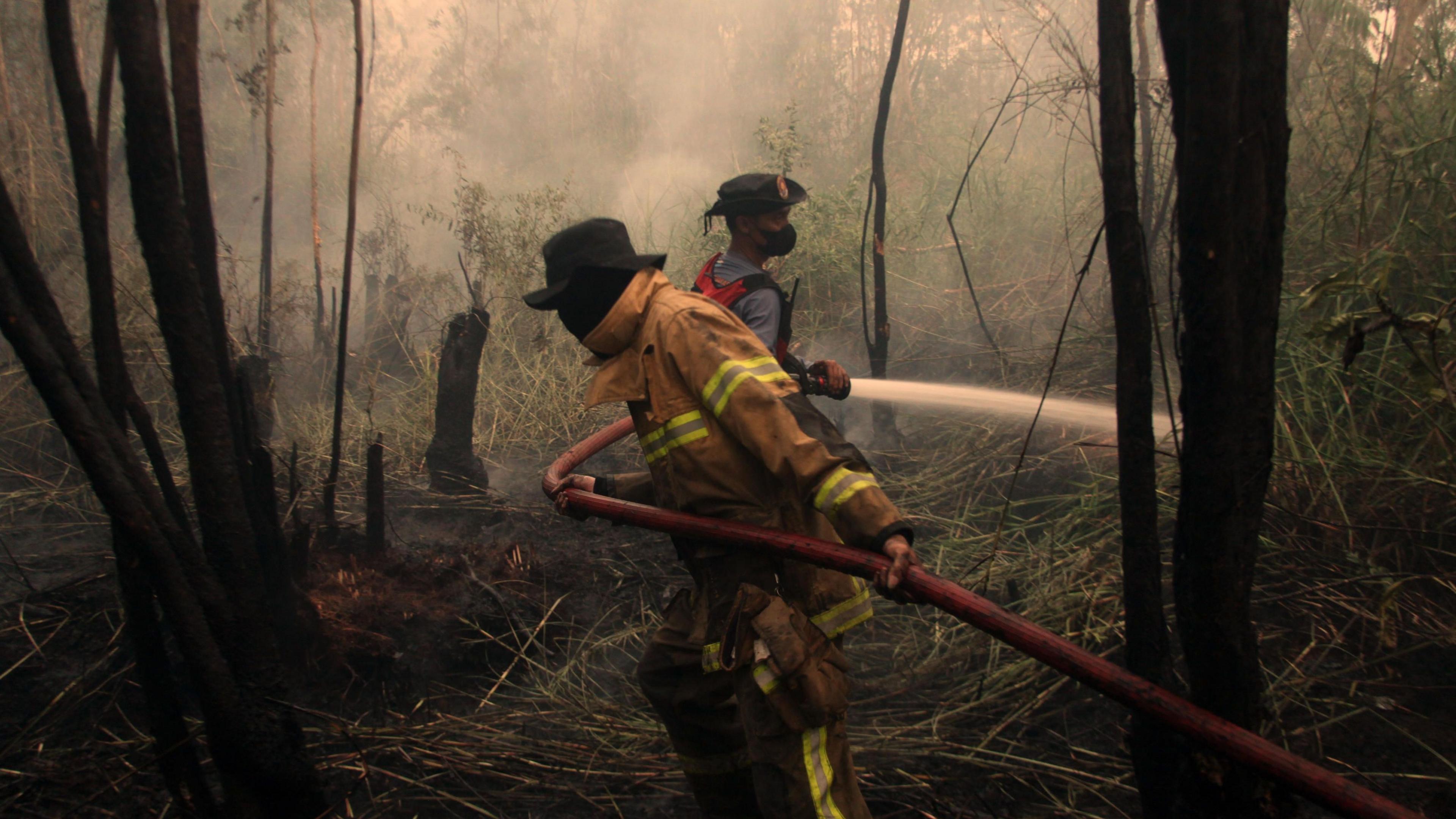 Figure: Firefighters in Indonesia battle wildfires sparked by El Niño-induced drought, affecting approximately 12.5 million people. Source: Anadolu / Getty Images, BBC
In South Asia, data from the India Meteorological Department reveals that the southwest monsoon delivered 15% less rainfall than normal through September 22. This moisture deficit threatens the autumn harvest for hundreds of millions of farmers and heightens volatility in global commodity and food markets.
The Atlantic presents an entirely opposite anomaly. As of late September, zero hurricanes have formed in the Atlantic basin throughout 2026, marking the latest date without a named hurricane since the advent of satellite storm tracking. This lull is directly attributable to El Niño: upper-atmospheric winds create intense vertical wind shear that behaves like an enormous atmospheric fan, tearing fledgling storm clouds apart before they can organize into tropical cyclones.
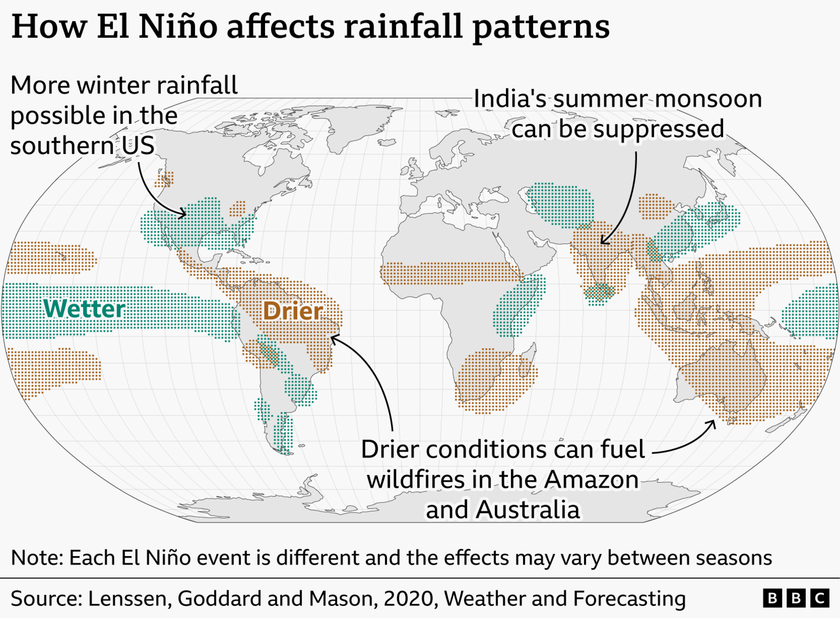 Figure: Map of typical global precipitation anomalies during El Niño: drier conditions across northern South America, Southeast Asia, and Australia; wetter conditions across the southern United States. Source: BBC Weather
While coastal Peru and Ecuador brace for torrential downpours and flood risks, Southeast Asia and Australia remain gripped by drought and brushfires. This extreme thermal anomaly is redrawing global precipitation patterns in real time.
Heat Reserves Eclipse Historical Records, and Climate Impacts Are Only Beginning
Surpassing historical temperature records weeks before the expected peak indicates that the underlying energy reserves of this El Niño exceed all historical benchmarks. Breaking records midway through its development proves that thermal energy accumulated within ocean depths is far greater than initially modeled.
Scientists caution that record-high sea surface temperatures do not automatically mean that weather disasters will double in severity in every corner of the earth; climate feedback mechanisms are intricate, and downstream consequences are still being evaluated.
Yet this is far from a distant, academic abstraction. From the price of staple grains and fruits at the supermarket to abrupt shifts in local weather, this planetary event touches daily life everywhere.
The fever burning across the equatorial Pacific has only revealed its opening act. As the late-year peak approaches, global weather systems will face far more grueling trials.
References:
- BBC Weather Report